StP Mo44c St-Fiacre Luftwaffe station K11
RADAR · K.V.Gruppe Morlaix · AOK 7 Brittany · France

StP Mo44c St-Fiacre Luftwaffe station K11
Luftwaffe station K11, E.Werk.
1 x Main garage, generator, fuel depot, in Sonderkonstruction.
2 x R622 Gruppe bunkers.
1 x SK Sendestation.
4 x Pos, concrete barracks.
1 x Flak on the roof of the SK Senderstation.
1 or 2 x L2 Flak emplacement or L408?.
6 x Vf58c Tobruk's.
1 x FuSAn721 Knickebein (dismantled in 1944).
1 x See Elefant - actually (1942 model "FuMG 402 Wasserman" radar).
1 x FuSE 62 A anti-aircraft radar and search light control.


StP Mo44c St-Fiacre Luftwaffe station K11

I have always wished to visit St Fiacre, StP44a. So on the 10 May 2026, I made it. I was hoping there would be somebody around and we could just get inside the compound at least. But no, there was know body anywhere to be seen.
You can get a view of the garage building, but only from the track and maybe over the hedge. It is now a shooting range and they do not want people wondering around. We continued past and to the top of the small hill. Knowing what was there, looking around and you could get an idea, but very little remains. Most covered in earth, piled up and undergrowth allowed to go wild. Still I have been there, seen it and as we say, DUN IT.
SHM plan
StP Mo44c St-Fiacre Luftwaffe station K11
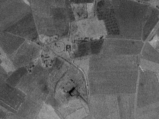
So what was it, there are a few websites that talk of 'Knickebein' stations. There were 13 in all stretching from Norway to Sicily. The basic Idea was a directional radio signal to help bomber pilots to find their way to their target, without too much trouble. The British bomber pilots navigated by Dead Reckoning.
So by using an electronic signal, it was much easer more accurate.
IGNF 1961


AIR 14-2909 Knickebein radio navigational stations REVISED
Exact co-ordinates.
Air 14/2909
StP Mo44c St-Fiacre Luftwaffe station K11

As the German army swept across France, they found that they could make more Knickebein stations, so they went from just two to 13, all over Europe.
10 May 2026


StP Mo44c St-Fiacre Luftwaffe station K11

The best view we could get from climbing up the earth bank.
10 May 2026

StP Mo44c St-Fiacre Luftwaffe station K11

A zoomed in picture where you can see the camouflage on the inside walls.
10 May 2026


StP Mo44c St-Fiacre Luftwaffe station K11

SK Sendestation plan.
A crew depot room.
Four garages behind large doors.
Workshop space.
Fuel depot.
Generator room.
Vehicle yard.
From Peters 2003.


A good picture of the vehicle yard and garages.
Patrimoine bzh 2002

A view taken from a French or American L4 light aircraft, they flew all around the coast, taking pictures post war of what the Germans built. The pictures and descriptions are held with Service Historique de la Défense (SHM).
Patrimoine bzh

StP Mo44c St-Fiacre Luftwaffe station K11

Continuing up the small hill.
10 May 2026


StP Mo44c St-Fiacre Luftwaffe station K11

The top of the hill looking north towards the sea in the very far distance. Behind the bunker, to the left the 1942 model "Wasserman S" radar (incorrectly called Elefant).
To our right the Knickebein site and the R622 bunker with its Flak Gruuppe.
10 May 2026

StP Mo44c St-Fiacre Luftwaffe station K11

My plan less two Tobruk's, I do not know where they were situated.
Built by the Todt Org. Started early in 1940 as a Luftwaffe radio guidance for the bombing of Britain. This would have been a FuSAn 721 Knickebein. This was a concrete circular base with a large square panel and it turned on a steal rail 360°. This with many more situated from K1 - Klepp Norway to K11 30 - Saint Fiacre. There are several websites that explain their uses.
A FuMG 402 Wassermann was introduced, but this type was just an aerial and not this thick 'Chimney' as allied intelligence called the. This one was a slim down version and the French Military called it a 'Pilon'.
There was also a FuSE 62 anti-aircraft radar and search light control.
IGNF


The aerial looks as though its just been built.
1943 RAF
StP Mo44c St-Fiacre Luftwaffe station K11

The small mound in front of the trees is the site of the R622 bunker.
10 May 2026


Knickebein (”Crooked Leg”) was the first system developed by the Germans for precision bomb attacks in England at night or in poor visibility.
Radio beams of about 30 MHz were aimed directly at the target and the bombers could hear from the radio in their cockpits when they were on the right track. This was achieved by having the two beams overlap in the centre. One beam would send a series of dots and the other a series of dashes. Provided the pilot could hear a steady note, he was exactly on course but if he drifted to one side or the other, he would hear dots or dashes, warning him to adjust his course to achieve a steady note again.
A further radio beam crossed the first ones, giving the navigator the distance to the target. At 250 km range, a target could be hit with an accuracy of +/- 1,500 metres. (By comparison, at that time and using ”dead reckoning” navigation, only 20% of British bombers were within 5 miles of their target.)
On the evening of 21 June 1940, a British aircraft was flying over East Anglia looking for radio beams and detected one aimed directly at the important Rolls-Royce aero engine factory in Derby. The air raid on that factory confirmed what British Intellence had feared and, as a response, British radio stations began to jam the German signals to disrupt the German raids. In turn, the German counter-measures meant, for example, that the cross-beam signal was first activated when the bombers were close to the target or that one or more wrong targets were identified.
In parallel, the Germans were embarking on a more precise system, which was also more difficult to jam, called X-Gerät. Although more complex to set up, it was much easier for the bomber crews. Five radio beams were used: two to set the course and three intersecting beams which would automatically drop the bombs on the exact target.
The remains of the Knickebein radio installations are very easily recognizable today because of the circular ring on which the antennae could be installed.
In total, 13 stations were built throughout Europe, and only the one in Sicily never became operational:
Kn-1 - Klepp - Norway - 22 km. south-southwest of Stavanger
Kn-2 Stollberg - Germany - 3 km. north-west of Bredstedt
Kn-3 Julianadorp - Holland - southwest of Den Helder
Kn-4 Kleve-Materborn - Germany - 58 km. northwest of Duisburg
Kn-5 Bergen op Zoom - Holland - 50 km. southwest of Rotterdam
Kn-6 Mont Violet - France - 13 km. southeast of Boulogne
Kn-7 Greny - France - 16 km. northeast of Dieppe
Kn-8 Mont Pinçon north Le Plessis-Grimoult - France - 30 km. southwest of Caen
Kn-9 Beaumont-Hague - France - 16 km. northwest of Cherbourg
Kn-10 Sortosville-en-Beaumont - France - 25 km. southwest of Cherbourg
Kn-11 Saint-Fiacre at Plestin-les-Greves - France - 17 km. northeast of Morlaix
Kn-12 Maulburg - Germany - 8 km. northeast Lörrach
Kn-13 Noto - Italy - 27 km. southwest of Syracuse (not completed)
https://www.battlefieldsww2.com/radiobeacon-stations-knickebein.html
The two in bold are both covered on www.atlantikwall.co.uk.
air 40/1691
StP Mo44c St-Fiacre Luftwaffe station K11

Knickebein, well if its around its under this mound?
10 May 2026


The RAF intelligence branch drew up maps, plans and air photos that pilots could look at. They could fly out from Cornish airfields and shoot up radars, gun positions, transport, supplies, trains and anything else they could find.
Target plan V/1 1941


Heading back down the hill. On the right are the two poles that held the electrics.

StP Mo44c St-Fiacre Luftwaffe station K11

The original electric poles which carried electrical current that was used as an electric fence around parts of the site.
10 May 2026

StP Mo44c St-Fiacre Luftwaffe station K11

10 May 2026


From : RAF Station, Medmenham.
To : Dr R.V. Jones, A.D.I. Science, A.M. Whitehall.
Date : 18 November 1942.
Ref : MIM/S. 1246/2/OPS.
W/T-Lanmour/ST.Fiacre K11
Sent herewith is a stereo pair of the latest photographs, No.s 2014 and 2015 of s/641,
taken on 10.11.42, of the Radionavigational, station at ST. FIACRE, N. of Lanmeur.
2. Since last photographed on 16.09.42, no change of any importance has occurred. To the N. of the turntable a new rectangular excavation, measuring 50 x 32 ft approx, with permanent sides, has been made, and a straight bit of trench, possibly for drainage, leads from it.
Group Captain, Commanding,
RAF Station, Medmenham.
(50ft x 35ft = 15.5m x 10.5m).
Air 14/2909 19 November 1942 via Pete

From Radio Air Nav:
"Wasserman S"
It is the mast of a 1942 model "Wasserman S" radar - without the actual antenna elements ?
In most publications it states it had a "Sea Elefant" radar, but actually it was a Wassermann S. I cannot find acurate details about this aerial/pylon.


From : RAF Station, Medmenham.
To : Dr R.V. Jones, A.D.I. Science, A.M. Whitehall.
Date : 17 January 1943.
Ref : MIM/S. 1246/2/G.
W/T-Lanmour/ST.Fiacre
Sent herewith is a stereo pair of the latest photographs, No.s 5109 and 5110 of s/685, taken on 2.1.43, of the Navigational Beam Station at ST. FIACRE, N. of Lanmeur.
Since 10.11.42, when its foundations were visible, a new single mast guyed at four points approx., 170ft. in height with slightly splayed out top, has been erected. Its position is 350 ft. on a bearing of 200° from the centre of the turntable and 170 ft. on a bearing of 270° from the nearest corner of the underground operations room. Between the "ops" room and the new mast are two shorter masts, 40 ft. high, all in alline.
Group Captain, Commanding,
RAF Station, Medmenham.
Air 14/2909 via Pete
StP Mo44c St-Fiacre Luftwaffe station K11

10 May 2026